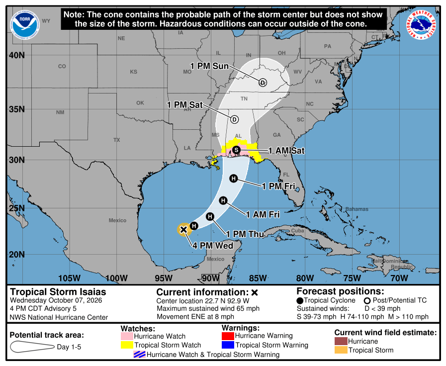
Tropical Storm Isaias: Map Shows New Track as Hurricane Expected Thursday
Summary
Tropical Storm Isaias is growing stronger and is expected to become a hurricane by Thursday morning. The storm is moving toward the northern Gulf Coast of the U.S. and could make landfall near the Florida-Alabama border late Friday or early Saturday, bringing heavy rain, strong winds, flooding, and storm surge.Key Facts
- Tropical Storm Isaias currently has winds of 65 mph and is about 500 miles south-southwest of the Mississippi River mouth.
- The storm is expected to become a hurricane by Thursday evening.
- It is forecast to hit land near the Florida-Alabama border late Friday night or early Saturday.
- Watches are in effect, including a Storm Surge Watch from Mississippi to Florida and a Hurricane Watch near parts of Mississippi, Alabama, and Florida.
- Rainfall of 8-12 inches is expected along the Gulf Coast, with significant flooding possible in Alabama and Florida.
- Alabama’s Governor Kay Ivey declared a state of emergency for 40 counties ahead of the storm.
- The highest storm surge of up to seven feet is expected in Alabama, the Florida Panhandle, and parts of Mississippi.
- President Donald Trump is scheduled to attend a football game in Alabama on Saturday but has expressed concern for people's safety if the hurricane becomes an emergency.
Read the Full Article
This is a fact-based summary from The Actual News. Click below to read the complete story directly from the original source.