New satellite will see through clouds to 'weigh' Earth's forests
Summary
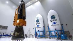
A groundbreaking satellite, named Biomass, will launch soon from the European Space Agency. Using advanced technology, the satellite plans to analyze Earth's forests to determine their 'weight', or how much carbon is stored in them, providing essential data for climate change researchers.Key Facts
- The Biomass satellite is a project led by Airbus, a British company.
- The goal of the satellite is to determine the carbon storage of Earth's forests, which helps combat climate change.
- Traditional means for measuring carbon storage in trees are challenging, hence the need for this satellite.
- The satellite is equipped with a large 12-meter diameter antenna that uses extended wavelength radar to view inside forests.
- This radar wavelength allows scientists to see beyond leaves and twigs, reaching deeper into the forests and better assessing tree compositions.
- The experts anticipate creating the first maps from the data within six months post-launch. They would then continue data collection for the subsequent five years.
- The Biomass satellite also features an ability to see through clouds, improving conventional satellite imaging which is usually obstructed in cloudy conditions.
- On-ground measurements will continue post-launch to ensure the data from the satellite is correct.
Read the Full Article
This is a fact-based summary from The Actual News. Click below to read the complete story directly from the original source.